Rock Bottom
Executive summary:
In the beginning there was shale ...
Starting some 800 million years back, it's a tale of magma up-wellings from the earth's hottest depths. Of the toings-and-froings over eons of continents adrift; when the continental Super-Mother fragments, inland seas form in which granular sedimentary layers pile up eight kilometers deep and compress into sandstone. (Table Mountain rock weathers away slower than most.) Another continental collision follows. The land lifts, folds. The Mountain forms.
Comprehending Table Mountain's Geomorphary
Of all the sciences it's worth giving the geologists some slack (and therefore hiking guides attempting to interpret their work too.) It's a relatively new field of understanding. To me reading the geologists' ideas can feel like watching a lava lamp.
The general idea: about 540 million years ago, below the super-continent where Table Mountain would later rise, a magma up-welling intruded into the existing metamorphic rocks.
On cooling, it formed a massive bolt of igneous granite.
The Seabed hardens
Tectonic forces caused the super-continent to drift apart. During many millions of years, over the earth's surface - (kind of present day Karooish?) - water-borne sedimentary sand built up in layers. Hardened into sandstone several kilometers thick, 8km, according to some estimates.
Continental Pushback
Later, as Antarctica, Australia and South America’s Falkland Plateau drifted and pushed back up against what we now call Africa, where the southern and western Cape currently is, the 8 km-thick sandstone-covered land buckled, folding concertina-like, and a process of subduction, when one of the colliding continental parties slips beneath the other, lifting the opposing continent landmass. At the same time, some say, the bolt of granite anchored the sandstone-laden earth above it, forcing the land on either side to rise. (Others counter this last theory, their thinking being is that this did not happen at other spots with granite under-girds, so why here?)
credit: Wikipedia (creative commons)
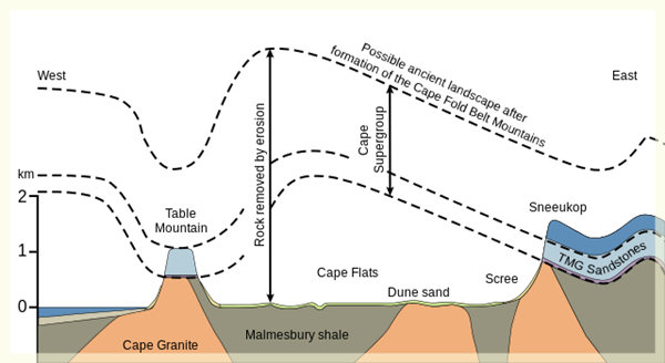
Is the Table Mountain flat top really an Ancient Riverbed?
The diagram's label describes a 'possible ancient landscape.' Some say the sandstone valley, where the top of Table Mountain is now, was flattened by running water.
The familiar emerges
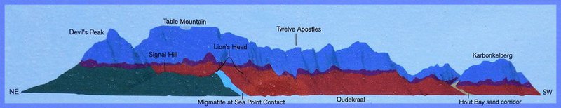
The modern mountain shaped itself round shale and the subterranean granite base that emerges over A Very Long Time. Table Mountain is thought to consists of the most durable rocks around, weathering away at between 2 -7 millimeters per 1000 years.
Slowly the geological shapes that we know as Lion’s Head and Signal Hill, as well as the rest of Table Mountain became the familiar shapes that dictate several factors unique to life in Cape Town - from tourism to the angle and ferocity of the weather; and societal and residential planning; traffic dynamics, and keen mountain rescuers.
Not so simple
So why is Table Mountain flat shaped?
Geology, like the material it describes is a long-ranging constantly evolving thing.
Older geology books offer a flattening formed by ice sheets.
How long will the theory of the iconic flattop being the remnant of an old valley hold up? It is credibly sourced. It makes some kind of sense as we tramp the mountain. And until some better story comes along, it will be how I try to stumble through my explanation of the ground beneath our feet's past six hundred million years, or so.
Much of the thinking outlined above comes from work done by John Compton. This is his YouTube channel.